In a world where technology increasingly bridges gaps between needs and solutions, finding routes that cater to specific preferences or requirements is becoming more accessible thanks to AI-enhanced mapping tools. These intelligent systems are not just improving conventional navigation but are paving the way for a more tailored travel experience.
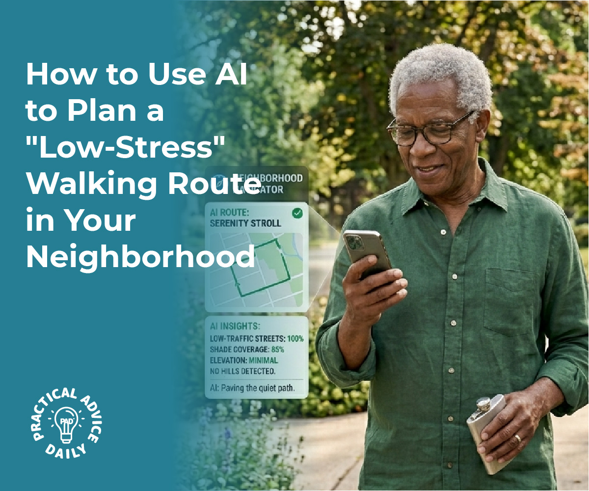
AI-powered maps can now identify routes with optimal shade, frequent benches for resting, or paths with minimal elevation changes, offering invaluable support for those with mobility concerns.

By analyzing real-time data and user preferences, AI is transforming how people plan their journeys. These advanced algorithms consider various factors, such as tree coverage for shade, landmarks for resting points, and terrain elevation, to suggest the most suitable paths. This level of personalization in route planning addresses diverse needs, helping individuals navigate urban landscapes with ease and confidence.
Whether it’s ensuring a comfortable walk for the elderly or providing a suitable path for wheelchair users, AI is revolutionizing route selection. As the technology continues to mature, it promises even more convenient and efficient ways to explore cities or nature, particularly for those looking for safer, more accessible travel options.
Table of Contents
Key Takeaways
- AI maps suggest shaded, flat, or bench-lined routes.
- Algorithms analyze data for personalized travel.
- AI advancements offer enhanced navigation solutions.
How AI-Enhanced Maps Identify Shade, Benches, and Flat Paths

AI-enhanced maps leverage advanced technologies to provide users with optimal routes. These maps help individuals find shaded pathways, locate benches for resting, and choose paths with minimal elevation changes, enhancing comfort and accessibility.
Mapping Shade and Sun Exposure on Routes
AI-powered route planning tools use real-time data integration and satellite imagery to identify shaded paths accurately. Technologies like CityShadeMapper utilize LiDAR data to create high-resolution maps that depict sun exposure and shade variations across urban landscapes. This allows users to select routes that offer more shade, reducing heat exposure during their journeys.
Tools like ShadeMap enable users to simulate sun and shadow movements, helping them plan walks that minimize sun exposure. These maps capture data at specific times, providing dynamic shade maps relevant to different times of the day and year, thus ensuring that users can adapt their routes according to changing environmental conditions.
Locating Benches and Resting Spots on Walking Paths
The integration of AI into digital mapping services like Google Maps allows for the identification of public amenities along walking routes. By analyzing satellite imagery and data crowdsourced from users, AI can mark the locations of benches and other resting spots.
This capability assists individuals who need frequent breaks, such as the elderly or those with medical conditions. Users benefit from knowing where they can rest, adding a practical layer to their journey planning. Such features encourage more people to walk by providing assurance that they will have places to rest along their way, thus making walking a more appealing and feasible option for diverse groups.
AI Detection of Path Elevation and Slope for Accessibility
For those with mobility concerns, the elevation and slope of a path are critical. AI technologies analyze topographic data and street-level images to determine path gradients. Services like Google Maps incorporate such technologies to highlight routes that are more accessible for wheelchairs and strollers, marking flat routes as favorable.
By using machine learning algorithms, maps can update in real time, providing information on construction or route changes that might affect path accessibility. This integration of AI ensures that users have reliable information, contributing to a more inclusive experience for individuals with varied mobility needs.
Core Technologies Driving AI Route Optimization

AI route optimization leverages several advanced technologies to efficiently plan paths, addressing unique considerations such as providing shaded routes, finding benches for resting, and selecting the flattest paths for those with mobility challenges. This involves combining real-time data analysis, machine learning, and sophisticated optimization algorithms.
Machine Learning and Predictive Analytics for Route Planning
Machine learning plays a crucial role in AI route optimization. These systems learn from historical data, enabling them to predict future traffic patterns and user needs. By applying predictive analytics, the technology anticipates various factors affecting travel routes, such as potential delays, estimated travel times, and the likelihood of encountering obstacles like steep inclines or unshaded areas.
This predictive capability is essential for crafting efficient and user-friendly routes, especially for users with specific mobility requirements. Using advanced models, AI can adjust and recommend optimal paths that consider environmental factors, ensuring accessible and pleasant navigation for all users.
Real-Time Data Analysis and Real-Time Traffic Updates
Real-time data analysis allows AI systems to respond to current conditions swiftly. This includes processing real-time traffic updates, weather conditions, and road closures to adjust routes on the fly. The integration of real-time data ensures that AI-generated routes are both safe and efficient.
By continually ingesting data from numerous sources, such as GPS signals and traffic cameras, these systems can dynamically reroute users to avoid congested or less desirable paths, providing alternate options that may have more shade or rest stops. This adaptability ensures that route suggestions remain relevant and effective at any given moment.
Optimization Algorithms and Multi-Objective Balancing
Optimization algorithms form the core of AI route planning by balancing multiple objectives to create the best possible route. Factors like minimizing travel time, reducing the difficulty of the path, and maximizing convenience are prioritized and balanced through complex computational methods. Multi-objective optimization is particularly beneficial for accommodating various user needs, such as finding routes with more shade or smoother terrains.
These algorithms evaluate each potential route against numerous criteria, ensuring that the selected path meets the specific preferences and conditions set by users. This nuanced, algorithm-driven approach guarantees that AI-enhanced maps deliver tailored routing solutions.
Personalizing Routes for Mobility, Comfort, and Accessibility
Incorporating AI-enhanced maps to navigate urban environments can significantly improve mobility for individuals with specific needs. These tools offer more than just basic navigation by optimizing routes for terrain flatness, available resting points, and environmental comfort.
Selecting the Flattest Paths for Mobility Concerns
AI route planners can be tailored to prioritize flatness in routes, which is crucial for those with mobility challenges. By leveraging topographic data and advanced mapping techniques, these systems can identify paths with minimal elevation changes. This approach minimizes physical strain, allowing users to traverse cities more comfortably.
The integration of multi-objective optimization allows an algorithm to consider factors like pedestrian safety and shortest distance while ensuring the path remains accessible. This adaptability is especially beneficial in urban areas with varied terrain, ensuring that the needs of the mobility-impaired are always a consideration in route planning. The end result is not only increased accessibility but also enhanced independence for many users.
Customizing Rest Opportunities Along Your Walk
Access to regular resting spots can transform a long journey into a much more manageable one. AI-powered navigation systems analyze urban landscapes to identify locations such as parks, benches, and shaded areas. These areas allow individuals to rest and recuperate during walks, essential for those who require frequent breaks.
Dynamic adaptability in these systems can also suggest alternative stopping points if regular ones are unavailable. This flexibility ensures the journey remains comfortable and safe under various conditions. By embedding rest stop data into the route planning process, users can better manage their energy and enjoy their surroundings at a more leisurely pace.
Dynamic Rerouting for Environmental Comfort
Navigating with a focus on environmental comfort involves more than a simple route adjustment—it’s about a holistic approach to journey enhancement. Dynamic rerouting enables users to avoid areas with high heat exposure, poor air quality, or extreme noise levels. With AI route planners, these environmental factors are taken into account to suggest more pleasant and safer pathways.
For instance, algorithms might prioritize tree-lined streets or routes through green spaces during high temperatures. This shift not only enhances physical comfort but also promotes sustainable urban living. Through continuous updates and real-time adaptability, routes can be adjusted dynamically to provide the most comfortable and efficient travel experience available.
Practical Tips and Emerging Trends in AI-Driven Route Selection
AI-enhanced maps offer valuable features for tailored route optimization, incorporating elements like shade, benches, and even terrain considerations for individuals with specific mobility requirements. These advancements ensure a more personalized and effective approach to navigating urban landscapes, highlighting user preferences in route planning.
Choosing the Right AI Route Planning Tools
Selecting the most suitable AI route planning tools requires an understanding of not only the software’s features but also its compatibility with user needs. Route planners should include options for personalized route suggestions based on various parameters, such as level paths or shaded areas. Integrating robust AI-powered optimization features ensures that these tools constantly learn from user feedback and real-time data.
Users should also consider the tool’s ability to provide ETA accuracy to ensure timely arrival. Comparing features and user reviews can assist in making informed choices for optimal experience and reliability. Essential functionalities to look for include real-time updates, route optimization abilities, and comprehensive mapping data.
Balancing Efficiency With User Preferences and Health Needs
While achieving routing efficiency is crucial, it’s equally important to accommodate user preferences and health considerations. AI-driven systems can now incorporate user-defined criteria, such as flat paths for wheelchair users or routes with frequent resting spots, without compromising speed. Additionally, factoring in environmental conditions or surrounding infrastructure can play a key role in making routes safer and more comfortable.
AI algorithms should be designed to handle complex user-specific requirements, such as shade or curb ramp availability, enhancing the route optimization process. By aligning route optimization software with individual preferences, these systems can serve diverse communities better while maintaining efficiency.
Future Trends: Green Routing and Community Mapping
Emerging trends in AI-driven routing emphasize eco-friendly choices and community-based mapping enhancements. Green routing aims to minimize environmental impact by selecting paths that reduce carbon emissions, supporting sustainability. This trend involves incorporating green zones and low-traffic areas into route planning decisions.
Simultaneously, using community feedback and local insights enables route planners to map routes that reflect real-world accessibility and usability. Technologies such as AI-powered route optimization and participatory mapping stand at the forefront, enabling more inclusive and environmentally conscious navigation solutions. These trends not only adapt to current transportation needs but also anticipate future shifts towards greener, more community-focused routing options.
Final Thoughts
Navigating the world should be an experience of joy and discovery, not a source of stress or physical strain. Thanks to AI-enhanced maps, the freedom to explore is being redefined for everyone, regardless of mobility needs. By turning complex data into simple, personalized routes, these tools act as a thoughtful guide—pointing out the quietest shaded paths, the most convenient resting spots, and the flattest ways to get from point A to point B.
As this technology continues to grow, it brings us closer to a future where our cities and parks are truly accessible to all. Whether you are planning a gentle afternoon stroll or navigating a busy urban center, these smart mapping features empower you to move with confidence and comfort. We encourage you to explore these tools today and see how a little extra help from AI can make your next journey your most pleasant one yet.